Day 6 Sakrivierpoort to Williston 090928 Monday 247 km 8h 15m
One of the VERNAC (Vernacular Architectural Society) members comes from Loxton. Her brothers have farms in the area; I stayed with Martin and Mariaan Scholtz of Sakrivierpoortplaas for the night. I had brought the 1:250 000 maps of the Sak river with me and Martin marked them up with his recommended route; basically the red dashed roads closest to the river.
Had a few beers, nice supper and wine before bed and was shown part of the farm. One interesting thing is martin keeps a few Nguni cattle which are the only ones that will eat fluitriet[/]. There are now two types of fluitriet; the smaller local variety and the larger, introduced, Spanish variety but both spread where ever there is shallow water but these cattle keep them in check. Besides merino sheep martin also grows garlic; large amounts have been imported from China completely disrupting the local market to the extent that the local farmers no longer hire seasonal part-time workers. In other words locals have lost their income because of these imports. Martin says the Chinese garlic is not at all bad but they imported so much and flooded the market with it that it stayed on the shelves for far too long and it has a limited shelf life so, in the end, it was very inferior garlic that was being sold.
Stupidly I have no photos of them or their nice farm. Lesson learned!

This is looking downstream from the poort soon after leaving Martin’s farm. This is, to me, the prettiest stretch of the Sak river. Later I will post a picture of the Vis river (a tributary of the Sak) valley which is, to me, really picturesque.

First real watercrossing on the Sak; right in the poort.

The Sak as it exits the poort.
Some more history
I recounted how there had been almost continuous commando activity for 10 years yet the trekboers were having to retreat under the continual raids by the San. In 1795 the Cape was taken over by the British (it continued until 1803 then the Dutch regained control until 1806 and then the British invaded & finally took control). With the new British authorities came a different approach to the border conflict problem. They sent John Barrow to assess the frontier problems (there were even bigger problems on the frontier with the Xhosa and that was the economically more important area). Barrow was accompanied by the landrost of Graaf-Reinet when he went to negotiate with the San to the north. The went as far as the Gariep (Orange) and the Tarka rivers but the San avoided them except for one small party the crept up on. Despite strict instructions from Barrow they were attacked and one was killed in cold blood; the landrost claiming that a shower of arrows had been fired at the party (Barrow was right there and knew it to be a lie). The actions of this (unrepresentative?) group of colonists greatly influenced the perceptions of the British of what the cause of the tension on the border was. I quote from the book:
Quote:
It is no exaggeration to state that the British policy towards the San, on both the eastern and northern frontiers, was shaped by Barrow’s experiences on this occasion. Barrow’s impression of the San was that they were ‘mild and manageable in the highest degree.’ In his opinion, they were far more sinned against than sinning, forced to retaliate as best they could against ‘the brutality and gross depravity of the boors’, who habitually enslaved their women and children while ceaselessly trying to drive them from their land. Though Barrow acknowledged that the loose political structures of the San made it difficult to negotiate a far-reaching peace, he became convinced that the prime cause of the hostilities existing between them and the colonists was the commando system.
Please note that that one brutal event shaped the British policy. There was a long and bitter sequence of events leading up to the ‘boor’ behaviour towards the San but Barrow formed his opinion on just this single event largley. The British policy was to partition the country with a definite border and each group should stick to their side of it – no exceptions whatsoever. This policy had been suggested by the veldwachtmeester of the Roggeveld, Floris Visser and it fitted in with what Barrow suggested to the Governor, MacCartney . Furthermore they decided to use missionaries to work amongst the San to convert them to a pastoral existence (in other words make them change from being San into being Khoikhoi; change from being hunter/gatherers to become pastoralists).

This is a map from the book. It shows the boundary following the Sak river as it flows across to where it joins the Riet (and Vis) rivers between present Willeston and Brandvlei (same level as Calvinia). To the right of the river was San territory, to the left was trekboer territory. Sakrivierpoort where I spent the night is just at the first kink in the river.
I followed it all the way up to the Gariep (Orange) river, though it changes its name to Hartbees along the way.
Only one mission station was established in the San area east of the Sak river by Kicherer of the LMS in Blydevooruitzig (near Canarvon probably) 1799 about 1 days journey north of the Sak river. In 1800 it was moved southwards to be on the Sak river. In 1806 it was abandoned as it had been dry between 1800 & 1806 – a serious drought period. The Sak river mission station is marked on one of the maps in the book as being slightly east of Fraserberg. I stumbled upon a drawing of it on the internet (& had huge trouble finding the source again).
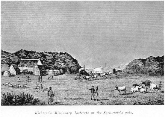
Look at the shape of those hills and compare them to the hills in the last two photos – just about the same except my hills are much bigger but did the artist reduce the size to fit the picture & look at the name ‘Sak-river’s gate’ = Sakrivierpoort. *source* I have ridden right down the river and, although this is a bit further east than the position shown in the book, I wonder if the mission was not right here.
The Mission policy did not work out. The San had an extremely rich and entrenched belief system so Christianity had no appeal or attraction for them. The missionaries could not speak their language which hardly helped. But the concept of converting an ancient society based on hunting and collecting veldkos who followed the game and veld through the seasons to be sedentary keepers of sheep and cattle was just a delusion by the authorities. One does not simply abandon your lifestyle.

Quite a bit further along at Robertskraal farm. I had got lost & had to turn back to get back on course. My version of the Garmin Topo maps is not the latest and is not routable. The topo maps are an utter disgrace as far as cartography goes. The background colour mari biscuit, the contours are thick dark brown lines but the secondary roads that are shown as red-dashed lines on a 1:250 000 map are tiny grey dashed lines on the Zumo – absolutely invisible when you are riding. If they reversed the contour & secondary road symbols it would be a huge improvement (& they could then make the grey lines a bit thicker to make them visible). I ride with the scale set to 200m. I used the 1:250 000 maps from here on until I went back to bigger roads on the way home. The topo maps are useless, T4A shows absolutely nothing & streetmaps never claimed to be any use in these conditions. Thank goodness i brought the 1:250 000 with.
Lots of water here.

The red dashed road I was riding.

I think that was the only river sign I saw saying Sak. A better bridge ahead.

The bridge with what I originally thought were Karee trees but now I wonder if they are not escaped poplars. Just about flowing still – that is a puddle under the bridge. That is a eucalyptus tree on the left – I wrote a little about them yesterday.

Looking downstream at the bridge.

The Sak is on my left. The nice road I was riding along. I am now riding in the Nieuweberge (old spelling) region. This was one of the two areas where the San were very strongly established (the other was Sneeuberg north of Graaf-Reinet). All the way to Williston that day I was in prime San territory. That is why the mission was built in this area.

The first dam. That is the earth dam wall on the right at the top of the picture. This is the track I went down to get right up to it.

The concrete spillway for the dam with the earth wall behind. Notice the slabs of rock. There were a few ducks and coots on the dam.

Leaving. There is still water in the river below the dam.

There was this drift on my road though that is not the actual Sak river. I like the picture as it was just the sort of thing I was looking for on this trip; all by myself far away from anybody.

I went past this corbelled building and took a photo of it and the co-ordinates on my GPS. What first got me to the area was these buildings. A friend of ours, Pat, is doing a masters degree about the corbelled buildings of the Karoo now that she is retired. There are quite a few of them but not much is known about them. She came on an exploratory trip and my wife Antonia, who is an archaeologist, went along to help her & I went along for the ride (not in the ‘on the bike’ sense of the word). I wrote up about them *here* The photo was just intended for Pat as a record so is not composed in any way.
The thing about a corbelled building it has a roof but no wood is used at all in its construction – except the doors if it has one & for some of the windows. I posted about poplar trees having been introduced into the Karoo; well this is what was sometimes done before those trees were available. Not much is known about them but Pat hopes to learn a lot and then we will know.
Notice the eucalyptus trees at this farmhouse. Also Peruvian pepper trees – the trees that are planted as shade trees at so many roadside lay-byes in the Karoo. They are good tough trees for this tough environment. Lots of wood at this place now but they are all introduced trees. Now there is timber to build with.

About an hour later at Maanhartskraal. Notice the white salt (?) deposit. Such a peaceful river here. It must be very brak but I did not taste it.

The bridge I took the photo from. Is it just this high to keep the road level or does the Sak come down in serious flood? The first I would think.

Turn off the R356 back onto red dashed road. You have it all to yourself out here.

Further along. The whole Karoo is peaceful. I really liked being here and I appreciate why the San cared for it so deeply.

Upstream.

Downstream. I crossed the Sak here at Weltevrede on a 1959 bridge but came back as that road leads away from the river and wanted to stay on my red-dashed route which keeps closer to the Sak. It would seem the farmer was just as weltevrede as the San used to be. People brought up in the Karoo are always happy when they get back. But it was noticeable on this trip how many farmhouses are no longer lived in. I don’t know the full story – partly many farmers now own more than one farm. A string of farms stretching from Loxton to Canarvon are all now owned by the same farmer.

My red dashed road went through this little drift but it is not the Sak.

Getting towards Williston. The Sak is now flowing through very level ground – it is where the line of green trees is to be seen on the left. Nice Karoo koppies in the background. Prime San territory I would think as they could live on the side of the koppies and check the game on the veld below

Sak river at Walkraal just outside Williston. The last of the water. There is a dam just upriver of here that I could not get to. I stayed in a B&B in Williston.


,,